File:Snowfield Peak 8648s.JPG
Jump to navigation
Jump to search


Size of this preview: 800 × 450 pixels. Other resolutions: 320 × 180 pixels | 640 × 360 pixels | 1,024 × 576 pixels | 1,280 × 720 pixels | 6,892 × 3,879 pixels.
Original file (6,892 × 3,879 pixels, file size: 8.78 MB, MIME type: image/jpeg)
Summary
| Description |
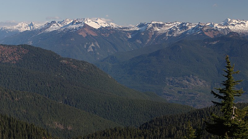
English: View across the Skagit River Valley of the northern portion of the south unit of North Cascades National Park: Snowfield Peak (left center skyline with cloud behind); The Needle (skyline, left of cloud); Big Devil Peak (middle distance); The Trapezoid (middle distance, centered below small cloud); Paul Bunyans Stump (skyline with shadowed north face); Pinnacle Peak (left skyline); Primus Peak (right skyline above Tsuga mertensiana in foreground; Little Devil Peak (middle distance skyline, left of Primus Peak)
|
| Date | 28 October 2013, 20:09:19 +00:00 |
| Source | Own work |
| Author | Walter Siegmund (talk) |
| Other versions |
|


| Camera location | | View this and other nearby images on: OpenStreetMap |
|---|
| Camera Model | Canon EOS DIGITAL REBEL XSi |
|---|---|
| Shutter speed | 1/200 |
| Aperture | f/11.0 |
| Film speed (ISO) | 400 |
| Focal length | 100.0 |
| Filter(s) | Hoya Circular Polarizer, HOCPMC67 |

|
This image is the work of Walter Siegmund
|
Licensing
I, the copyright holder of this work, hereby publish it under the following license:
This file is licensed under the Creative Commons Attribution-Share Alike 3.0 Unported license.
- You are free:
- to share – to copy, distribute and transmit the work
- to remix – to adapt the work
- Under the following conditions:
- attribution – You must give appropriate credit, provide a link to the license, and indicate if changes were made. You may do so in any reasonable manner, but not in any way that suggests the licensor endorses you or your use.
- share alike – If you remix, transform, or build upon the material, you must distribute your contributions under the same or compatible license as the original.
File history
Click on a date/time to view the file as it appeared at that time.
| Date/Time | Thumbnail | Dimensions | User | Comment | |
|---|---|---|---|---|---|
| current | 17:03, 14 January 2015 | | 6,892 × 3,879 (8.78 MB) | Wsiegmund |
File usage
The following page uses this file: