File:Pinus pinea range.svg
Jump to navigation
Jump to search


Size of this PNG preview of this SVG file: 800 × 474 pixels. Other resolutions: 320 × 190 pixels | 640 × 379 pixels | 1,024 × 607 pixels | 1,280 × 758 pixels | 1,435 × 850 pixels.
Original file (SVG file, nominally 1,435 × 850 pixels, file size: 725 KB)
Summary
| Description |
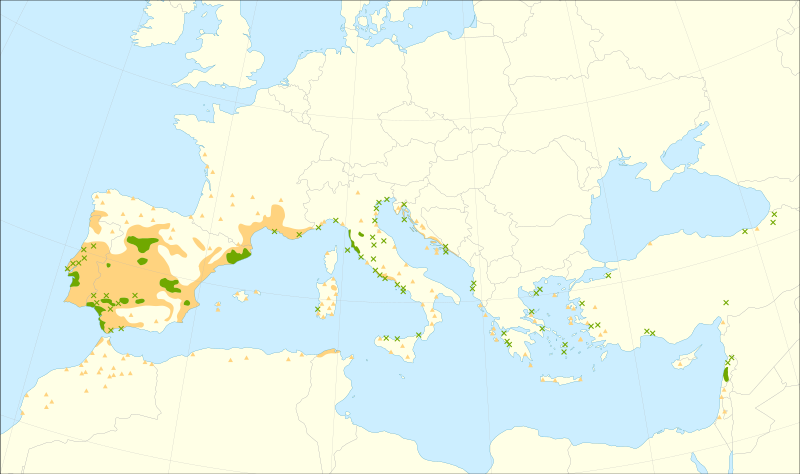
English: Distribution map of Pinus pinea L. (stone pine).
|
| Date | |
| Source |
Caudullo, G., Welk, E., San-Miguel-Ayanz, J., 2017. Chorological maps for the main European woody species. Data in Brief 12, 662-666. DOI: 10.1016/j.dib.2017.05.007
|
| Author | Giovanni Caudullo |
Licensing
I, the copyright holder of this work, hereby publish it under the following license:
This file is licensed under the Creative Commons Attribution 4.0 International license.
- You are free:
- to share – to copy, distribute and transmit the work
- to remix – to adapt the work
- Under the following conditions:
- attribution – You must give appropriate credit, provide a link to the license, and indicate if changes were made. You may do so in any reasonable manner, but not in any way that suggests the licensor endorses you or your use.
File history
Click on a date/time to view the file as it appeared at that time.
| Date/Time | Thumbnail | Dimensions | User | Comment | |
|---|---|---|---|---|---|
| current | 02:27, 27 May 2020 | | 1,435 × 850 (725 KB) | Giovanni Caudullo | Updated map with new references |
File usage
The following page uses this file: