File:Lavandula angustifolia - Köhler–s Medizinal-Pflanzen-087.jpg

From Eat Every Plant
Jump to navigation Jump to search

Lavandula_angustifolia_-_Köhler–s_Medizinal-Pflanzen-087.jpg(438 × 597 pixels, file size: 158 KB, MIME type: image/jpeg)

This file is from Wikimedia Commons and may be used by other projects. The description on its file description page there is shown below.

Description
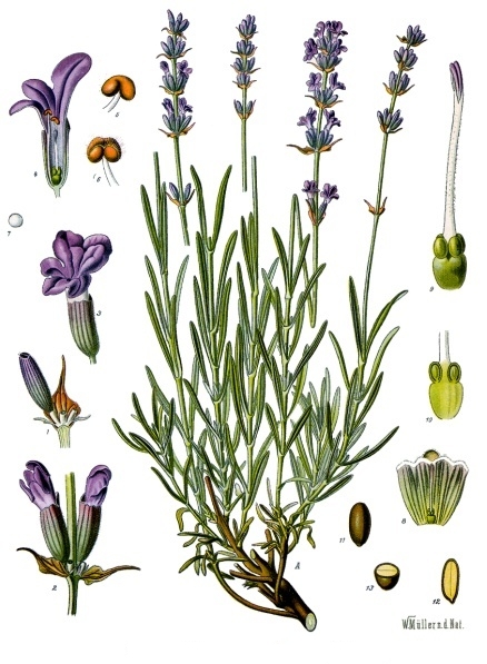
Deutsch: Lavendel. A blühende Pflanze, natürl. Grösse; 1 Zweigstück mit Kelch und Deckblatt, vergrössert; 2 Zweigstück mit 2 Blüthen, desgl.; 3 Blüthe, desgl.; 4 dieselbe im Längsschnitt, desgl.; 5 Staubgefäss, desgl.; 6 dasselbe, geöffnet, desgl.; 7 Pollen, desgl.; 8 Stempel mit aufgeschnittenem Kelche, desgl.; 9 Stempel, stärker vergrössert; 10 unterer Theil des Stempels mit Scheibe, zerschnitten, desgl.; 11 Same, desgl.; 12, 13 derselbe im Quer- und Längschnitt desgl.
Latina: Lavandula angustifolia.
Русский: Лаванда узколистная. A — цветущее растение; 1 — часть ветви с чашечкой и прицветником; 2 — часть ветви с 2 цветками; 3 — цветок; 4 — то же в продольном разрезе; 5 — тычинка; 6 — то же, вскрывшаяся; 7 — пыльца; 8 — пестик с разрезанной чашечкой; 9 — пестик, увелич.; 10 — нижняя часть пестика с нектарным диском, в разрезе; 11 — семя; 12, 13 — то же в продольном и поперечном разрезе.
Date
Source List of Koehler Images
Author Franz Eugen Köhler, Köhler's Medizinal-Pflanzen
Permission
(Reusing this file)
Public domain

This work is in the public domain in its country of origin and other countries and areas where the copyright term is the author's life plus 70 years or fewer.


You must also include a United States public domain tag to indicate why this work is in the public domain in the United States.
This file has been identified as being free of known restrictions under copyright law, including all related and neighboring rights.
OpenStreetMap
InfoField
Way 904749111
Object location49° 18′ 25.9″ N, 6° 15′ 13″ E Edit this at Structured Data on Commons Kartographer map based on OpenStreetMap.View this and other nearby images on: OpenStreetMapinfo

Captions

Add a one-line explanation of what this file represents

image/jpeg

49°18'25.92"N, 6°15'12.96"E

161,381 byte

597 pixel

438 pixel

e3c4f59340c9b28c634369734bdedb00ff0628eb

File history

Click on a date/time to view the file as it appeared at that time.

Date/TimeThumbnailDimensionsUserComment
current13:28, 26 January 2007Thumbnail for version as of 13:28, 26 January 2007438 × 597 (158 KB)Editor at LargeRemoving label from image; information is in the summary and can be added as a caption

There are no pages that use this file.